PROJECT SUMMARY:
2020 Identification & Measurement of Non-Functional Turf
Carpinteria Valley Water District (CVWD)
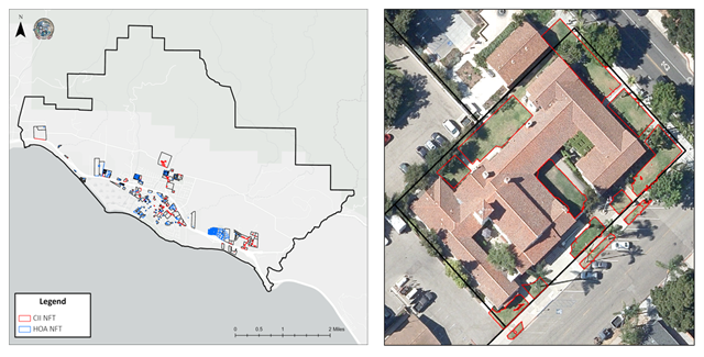
Carpinteria Valley Water District (CVWD) collaborated with DCSE to assess Non-Functional Turf (NFT) in homeowner associations (HOA), along street medians, and within and adjacent to commercial, institutional, and industrial (CII) areas. In alignment with the broader trend among water districts, CVWD aimed to encourage the replacement of ornamental turf with water-saving, drought-tolerant plants. Using remote sensing and photo interpretation techniques, DCSE located and measured NFT areas within the 11,300-acre district.

DCSE utilized very-high-resolution aerial imagery from 2020 and machine learning classifiers to distinguish between nine land cover categories. Through extensive sample collection and model training, the classifier achieved a 97% accuracy in differentiating between vegetation types, impervious surfaces, and water bodies. Crucially, the model accurately classified turf grass areas, which are candidates for non-functional turf. Using the turf class as a reference, NFT areas were further obtained through a selection/refinement process that combined automated and manual image processing techniques.
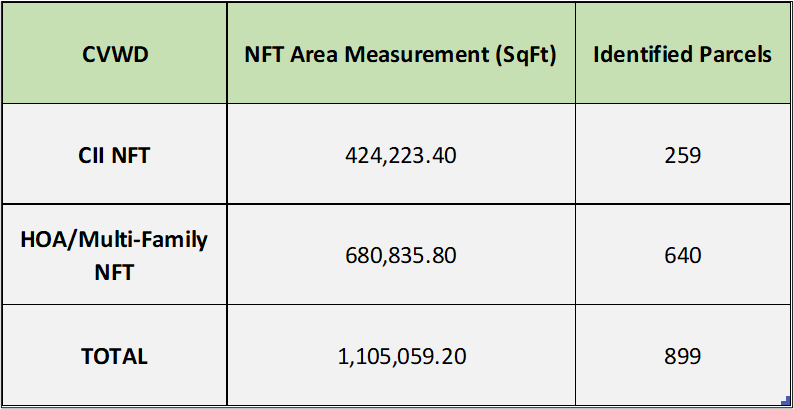
The final output provided the estimated square footage of NFT within HOAs and CIIs along streetscapes, sidewalks, and parking lots. The NFT polygon outputs. The NFT polygon outputs form the foundation for assessing the effectiveness of ornamental turf removal efforts, measuring both financial and environmental advantages.
Results were summarized and delivered in image raster files, GIS layers, and Excel formats. A complimentary ESRI Turf dashboard was designed and configured for data access and visualization.

HIGHLIGHTS
- Employs innovative remote sensing and imagery analysis methods
- Identifies and measures NFT
- Land cover Classification results with 97% accuracy
BENEFITS
- Results help water agencies to create efficient outdoor irrigation programs
- Produces accurate and current landscape data
- Analysis helps agencies create a road map for complying to state water efficiency standards
PROJECT OWNER
- Carpinteria Valley Water District (CVWD)
REQUEST MORE INFORMATION
Want to learn more about this Project, or how DCSE can provide similar services for your organization? Let us know by filling out our form through the link to our Contact Page below.
LOCATION
DCSE Inc.
23461 S. Pointe Drive
Suite 300
Laguna Hills, CA 92653
© 2024 DCSE Inc. All Rights Reserved

