PROJECT SUMMARY:
2022 Land Cover Classification & NFT Identification
Rancho California Water District (RCWD)
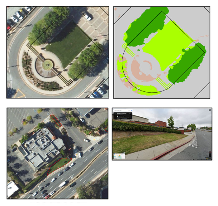
To evaluate non-functional turf (NFT) grass at both district and parcel levels, Rancho California Water District (RCWD) commissioned DCSE Inc. to develop a land cover classification model capable of distinguishing turf grass in high-resolution aerial imagery.

By integrating height information extracted from elevation data and utilizing 15 cm aerial imagery from 2022, DCSE successfully differentiated turf from shrubs and trees. This innovative data fusion approach, coupled with a well-trained machine learning model, achieved an impressive 98% accuracy, surpassing results from classification approaches reliant solely on spectral information or remote sensing indices.
With precise land cover information, DCSE measured irrigable irrigated, irrigable non-irrigated, and non-irrigable areas for the RCWD service area and its 45,000 residential and non-residential parcels. Additionally, candidates for NFT were pinpointed. NFT areas were further delineated through a selection/refinement process that combined both automated and manual remote sensing and photo interpretation processes.
The final output identified and measured NFT for 6,500 commercial, institutional, and industrial (CII) and homeowner association (HOA) parcels, encompassing an estimated 7.5 million square feet of NFT within the RCWD service area. By identifying locations of NFT that provide little or no recreational or community benefit, DCSE aids water districts in formulating conservation that replace water-intensive landscapes.
Results were summarized and delivered in image raster files, GIS layers, and Excel formats. A complimentary ESRI Turf dashboard was designed and configured for data access and visualization.

HIGHLIGHTS
-
Identifies and measures non-functional turf
-
Utilizes height information to better distinguish vegetation types
-
Classification results with 98% accuracy
BENEFITS
- Produces accurate and current landscape data
- Assists with targeted water conservation measures and programs
- Analysis helps agencies create a road map for complying to state water efficiency standards
PROJECT OWNER
- Rancho California Water District (RCWD)
REQUEST MORE INFORMATION
LOCATION
DCSE Inc.
23461 S. Pointe Drive
Suite 300
Laguna Hills, CA 92653
© 2024 DCSE Inc. All Rights Reserved

