PROJECT SUMMARY:
Estimating Irrigable Areas of Parkway Strips
Multiple Water Agencies
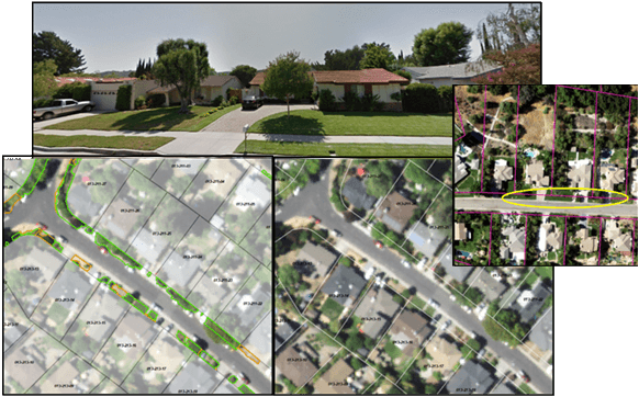
DCSE has developed a Parkway Extraction Model to address the problem where significant residential irrigable areas are being ignored in water budget calculations.
Parkway strips technically fall outside of parcel boundaries, but irrigation is still the responsibility of residents. Parkways can be areas between sidewalks and streets and/or lawn strips that fall between a sidewalk and the street curb. DCSE’s tool will help to extract these areas and to determine how much the total irrigable landscape of residential parcels will increase by including parkways/front yards areas in their irrigable area calculations.

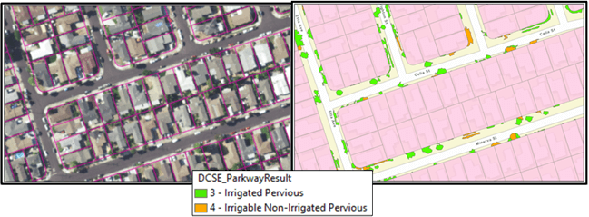
Using our designed Parkway Extraction Model and the Landcover Classification data, DCSE conducted analyses in four different water districts in California. The result shows that an accurate water budget calculation needs to be based on actual irrigated area that is fed run through each meter.
By merely including the irrigable area within the parcel boundaries and ignoring the parkway areas, we can have an error up to 19% in the water budget allocation. It was concluded that by including the parkway/front yard areas in the irrigable area calculations, the total irrigable-irrigated landscape (such a trees and turf grass) of the residential parcels was increased by 8.1 to 19%, and the total irrigable-not irrigated area (such as bare soil/brown lawns) was increased by 4.9 to 13%.

HIGHLIGHTS
- Distinguishes parkways & their influence on water consumption
- Utilizes land classification to identify additional irrigable landscape areas
- Query, analyze & visualize irrigable areas at parcel level that residents are responsible for
BENEFITS
- Enables DCSE to visualize and identify data to compile variance requests for Agencies
- Allows for the formulation of an accurate water budget based on actual water demand
PROJECT OWNERS
- Marin Municipal Water District
- City of Hayward Public Works & Utilities
- Oildale Mutual Water Company
- Oak Park Water Service
REQUEST MORE INFORMATION
Want to learn more about this Project, or how DCSE can provide similar services for your organization? Let us know by filling out our form through the link to our Contact Page below.
LOCATION
DCSE Inc.
23461 S. Pointe Drive
Suite 300
Laguna Hills, CA 92653
© 2024 DCSE Inc. All Rights Reserved

