GROWMAS
Geospatial Resources of Water Management for
Agricultural Systems
![]() Geospatial Resources of Water Management for Agricultural Systems (GROWMAS) is an online analytical platform which empowers local water agencies and Groundwater Sustainability Agencies (GSAs) to monitor, analyze and visualize historical and near real-time groundwater changes. GROWMAS provides Monthly and Annual Net To/From Groundwater (NTFGW) maps to agencies and helps them to achieve the groundwater sustainability.
Geospatial Resources of Water Management for Agricultural Systems (GROWMAS) is an online analytical platform which empowers local water agencies and Groundwater Sustainability Agencies (GSAs) to monitor, analyze and visualize historical and near real-time groundwater changes. GROWMAS provides Monthly and Annual Net To/From Groundwater (NTFGW) maps to agencies and helps them to achieve the groundwater sustainability.
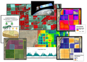 GROWMAS uses the Mapping Evapotranspiration at High Resolution with Internalized Calibration (METRIC) as the engine to calculate spatial actual evapotranspiration values – at the field level – in a given area through an automated system. It incorporates the estimated ET values with surface water delivery, spatial precipitation, and runoff data in the region to create spatial monthly and annual Net To and From Groundwater (NTFGW) maps.
There is no need for any metered groundwater pumping data, and the historical satellite imagery data are freely available. GROWMAS processes the satellite imagery and integrates several sources of data under one platform.
GROWMAS is a user-friendly online portal that automates the production of Monthly NTFGW maps of a region. It offers ongoing support to local agencies looking to develop and implement a Groundwater Sustainability Plan (GSP).
Related Links:
REQUEST A DEMO OR MORE INFORMATION
Reach out to us to learn more about the benefits of GROWMAS for your agency.
HIGHLIGHTS
- Enterprise Groundwater Resources Management
- Historical & Near Real-Time ET & Groundwater Changes Visualization
- No Need for Any Metered Groundwater Pumping Data
- Uses Freely Available Data & Historical Satellite Imagery
BENEFITS
- User-Friendly Automated Online Portal
- Ease of Data Accessibility (View Monthly Generated Maps of ET, Irrigation Deliveries, Groundwater, Fallowing/Crop Types – all in One Unified Web Platform)
- Monitoring Groundwater Pumping & Recharge at the Field Level
- Ongoing Support for GSAs To Achieve Groundwater Sustainability
LOCATION
DCSE Inc.
23461 S. Pointe Drive
Suite 300
Laguna Hills, CA 92653

© 2023 DCSE Inc. All Rights Reserved